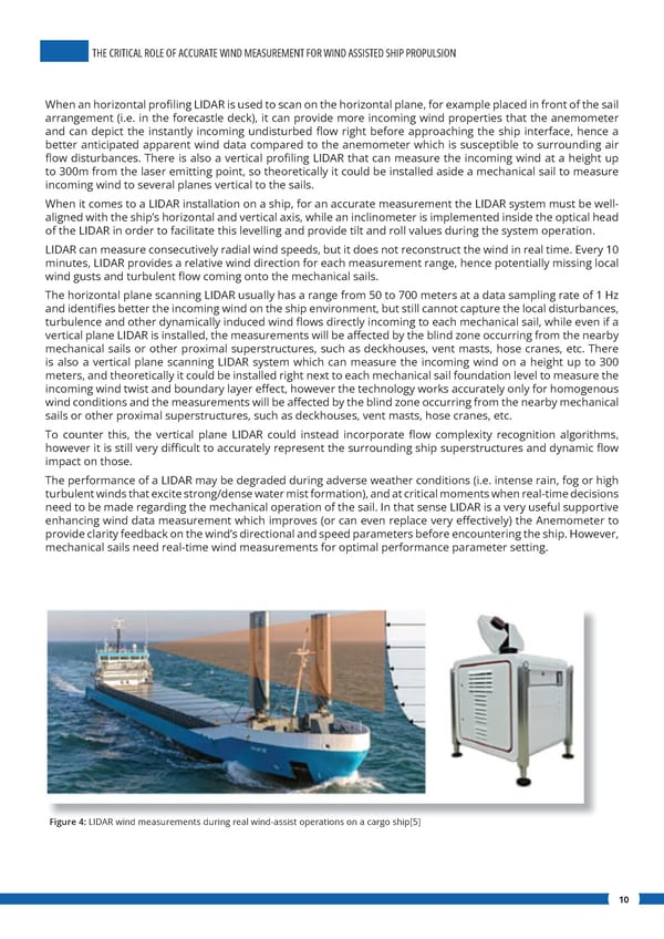
THE CRITICAL ROLE OF ACCURATE WIND MEASUREMENT FOR WIND ASSISTED SHIP PROPULSION When an horizontal pro昀椀ling LIDAR is used to scan on the horizontal plane, for example placed in front of the sail arrangement (i.e. in the forecastle deck), it can provide more incoming wind properties that the anemometer and can depict the instantly incoming undisturbed 昀氀ow right before approaching the ship interface, hence a better anticipated apparent wind data compared to the anemometer which is susceptible to surrounding air 昀氀ow disturbances. There is also a vertical pro昀椀ling LIDAR that can measure the incoming wind at a height up to 300m from the laser emitting point, so theoretically it could be installed aside a mechanical sail to measure incoming wind to several planes vertical to the sails. When it comes to a LIDAR installation on a ship, for an accurate measurement the LIDAR system must be well- aligned with the ship’s horizontal and vertical axis, while an inclinometer is implemented inside the optical head of the LIDAR in order to facilitate this levelling and provide tilt and roll values during the system operation. LIDAR can measure consecutively radial wind speeds, but it does not reconstruct the wind in real time. Every 10 minutes, LIDAR provides a relative wind direction for each measurement range, hence potentially missing local wind gusts and turbulent 昀氀ow coming onto the mechanical sails. The horizontal plane scanning LIDAR usually has a range from 50 to 700 meters at a data sampling rate of 1 Hz and identi昀椀es better the incoming wind on the ship environment, but still cannot capture the local disturbances, turbulence and other dynamically induced wind 昀氀ows directly incoming to each mechanical sail, while even if a vertical plane LIDAR is installed, the measurements will be a昀昀ected by the blind zone occurring from the nearby mechanical sails or other proximal superstructures, such as deckhouses, vent masts, hose cranes, etc. There is also a vertical plane scanning LIDAR system which can measure the incoming wind on a height up to 300 meters, and theoretically it could be installed right next to each mechanical sail foundation level to measure the incoming wind twist and boundary layer e昀昀ect, however the technology works accurately only for homogenous wind conditions and the measurements will be a昀昀ected by the blind zone occurring from the nearby mechanical sails or other proximal superstructures, such as deckhouses, vent masts, hose cranes, etc. To counter this, the vertical plane LIDAR could instead incorporate 昀氀ow complexity recognition algorithms, however it is still very di昀케cult to accurately represent the surrounding ship superstructures and dynamic 昀氀ow impact on those. The performance of a LIDAR may be degraded during adverse weather conditions (i.e. intense rain, fog or high turbulent winds that excite strong/dense water mist formation), and at critical moments when real-time decisions need to be made regarding the mechanical operation of the sail. In that sense LIDAR is a very useful supportive enhancing wind data measurement which improves (or can even replace very e昀昀ectively) the Anemometer to provide clarity feedback on the wind’s directional and speed parameters before encountering the ship. However, mechanical sails need real-time wind measurements for optimal performance parameter setting. Figure 4: LIDAR wind measurements during real wind-assist operations on a cargo ship[5] 10
 The Critical Role of Accurate Wind Measurement for Wind Assisted Ship Propulsion Page 9 Page 11